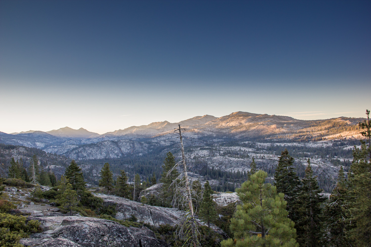
The hike and day as they lay ahead. Highland Lake is between the two highest peaks just to the right of center.
By:
Mike Mullen | Added over 12 years ago.
As fall settled into the mountains Highland Lake began to appeal as a hiking destination. I had been thinking of attempting a longer hike, and with a trip to Tahoe on the calendar as well as the opportunity to be dropped off and picked up at different trailheads a long thru-hike began to take shape.
The route would combine some familiar places along the Rubicon trail near the northern boundary of Desolation Wilderness, as well as the Eagle Lake trail from Emerald Bay up to the Velma Lakes. The middle section, connecting these two ends, would all be new to me and include the mysterious, and ultimately elusive, Highland Lake. Having just resolved to visit each of the named lakes within Desolation Wilderness, Highland Lake especially appealed to me because it is one of the most remote. Also included on the new lakes list would be Lake Zitella, Horseshoe Lake and the 4-Q Lakes.
As September turned into October, I finalized my proposed route, along with an alternate route that would eliminate some elevation change, reduce the off trail distance as well as the overall distance, but also miss many of the previously unvisited lakes. I did some long hikes in the city to get a feel for the distance and by mid-October I felt ready.
In the early morning of October 19th, 2013 I was dropped off at the Pacific Crest Trail trailhead just over Baker Pass from Lake Tahoe. As I watched the headlights of the car sweep away I stood in the densely quiet pre-dawn gloom made bright by an almost full moon setting in the west. As the PCT sets off to the south from Barker Pass it slowly loses elevation as it passes through high open meadows spaced between dense stands of trees. In the open the moonlight was more than enough to see by, and my flashlight was only needed in the forested sections. Patches of snow and ice, from recent early season storms, glowed on the trail near the pass becoming less and less frequent as I lost elevation.
After a couple miles of gentle downward traversing on the PCT I met the OHV route through Barker Meadows that would take me to the Rubicon jeep trail a couple miles ahead. The familiar site of Barker Meadows was illuminated by enough daylight to stow my flashlight and down coat. Leaving the meadows and crossing Barker creek for the second time I quickly reached the junction with the Rubicon jeep trail. I had forgotten how hard it is to walk on the Rubicon “trail,” thick dust, loose rocks and a generally treacherous walking surface make for slow going. The first section of jeep trail meanders through mixed open granite and stands of trees while holding a generally steady elevation. After a short time a large open granite area to the west opens up and must be used as a gathering place for the heavy summer time jeep traffic the Rubicon Trail attracts. I took a break here to take advantage of the excellent view to the south and a good portion of the remainder of my days travels. Large pools in the Rubicon River glinted through the trees in the valley below, and farther on the peaks near Highland Lake were visible. A lot more walking laid ahead of me, and I set-off, hoping to reach Rockbound Lake before having my breakfast. The jeep route continued to prove a slow and difficult walking surface as it steadily lost elevation along a series of switchbacks. I was happy to reach the valley floor and start making better time on the smoother surface of the road as it parallels the Rubicon River on its way south to Buck Island Reservoir. Crossing the iron truss bridge on the far side of the Rubicon Springs camp was a relief as my time in jeeper territory was coming to an end. On the way up to the ridge above Buck Island I encountered a jeeper whose jeep had slipped off the road and was lodged against a tree about 15 feet below the road. He had help on the way and so I headed on up to the ridge.
I was happy to leave the Rubicon Trail and it’s mysterious jeep culture behind and set-off cross-country from the saddle above Buck Island. Skirting the eastern shore of the reservoir would bring me to the stream connecting Rockbound and Buck Island reservoirs which I hoped to be able to cross. My last visit to the area was in the early spring and the creek was a completely impassable torrent, so I had been worried about this crossing. Not being able to cross here would mean a time consuming detour around the eastern side of Rockbound. My worries were for not as there was essentially no running water between the two lakes, and the crossing was a simple step over a trickle running across water polished granite. I hit the trail just past the “crossing” and quickly met the wilderness boundary sign. From this point on I would see only two hikers near the Velma Lakes.
After stopping briefly at the north end of Rockbound I skirted the shore on my way south and eventually hit the Rockbound Trail leading from the northern boundary of the wilderness all the way to Lake Aloha and on to Echo Lakes and the southern boundary near Highway 50. The trail in this section follows the old construction road left over from the hydroelectric project that was built in the 1960s just before official Wilderness designation was granted in 1969. Easy walking along the trail/road took me to the southern end of Rockbound where I stopped for breakfast on the shore of the lake.
Rockbound was where I had to decide whether to take the alternate short cut along the Rockbound trail roughly following the Rubicon River’s course through Rockbound Valley, or leave the established trail and aim cross-country for Highland Lake reconnecting to a marked trail on the maps at Lake Zitella. Having estimated the time I would need to leave Rockbound via the off trail route to Highland Lake carefully beforehand, I knew that time might be an issue. My plan called for leaving Rockbound about the time I stopped for breakfast, so I was past my self-imposed cut-off time for the longer route. Despite this I couldn’t resist Highland Lake and left the trail before it started down toward Rubicon Reservoir. From this point I had a good view of the reservoir which was very low at this late season.
The cross country route to Highland Lake proved to be very slow going, I stayed to the east of the creek coming from Highland Lake and wasn’t able to hold a very direct path. Many small, but very steeply sided, draws ran perpendicular to my desired track and required a lot of extra walking to get past. Eventually I had worked my way up the long drainage coming down from Highland Lake and arrived at a spot where a left hand course would take me up a boulder field and to a saddle in the ridge above Lake Zitella, and a route to the right would continue a quarter mile or so up to Highland Lake. But this right hand section would be an out and back to return to my main route to Lake Zitella and ultimately on to my scheduled pick-up at Emerald Bay. After carefully considering the time and conditions I decided to forego Highland Lake and turned left up to the saddle above Lake Zitella. The route up to the saddle took me through a narrow boulder field against a cliffy wall to the right and sweeping views off to the left looking north back toward the beginning of my hike at Barker Pass. A light dusting of snow persisted in the shade of rocks and trees here and crunched under foot on the climb up.
On some maps a trail is marked here, but I saw little evidence of a trail on the ground. It was clear that some fellow hikers come this way, but not many. A gentle descent from the saddle to the northeast shore of Lake Zitella brought me to a nice shaded spot with a view of the lake and the large mounding of granite separating Lake Zitella from the elusive Highland Lake. I stopped here for lunch, and enjoyed the unseasonable warm weather. At this point my planned pick-up at Eagle Lake Trailhead began to loom, as I was beginning to lag behind my time targets. After a short lunch and rest on the shore of the Lake Zitella, I headed east toward Horseshoe Lake.
A quick walk over a modest rise followed by a gentle slope down to the grassy northern shore of Horseshoe Lake was quick and easy. Still not having encountered a trail I decided to give up trying to find the trail marked on my maps and charted a cross-country route southeast from the outlet stream of Horseshoe Lake. Aiming for the 4-Q Lakes while not gaining or losing any extra elevation. This route took me across large smooth sections of sloped granite and was very easy going. I imagine that in spring and summer this might be nearly impossible with snowmelt water running everywhere. My cross-country route cut off a right angle elbow in the phantom trail on the maps and saved me some elevation change to boot. After slowly descending to the creek draining from McConnell and 4-Q Lakes I crossed the creek and quickly found a more established trail leading up to the 4-Q lakes. A very old and battered sign on the trail warned that the trail to Horseshoe Lake was impassible, and so I was especially pleased with my decision to abandon the hunt for the trail. A short jaunt up the trail brought me to the first of the 4-Q Lakes, which are a maze of rock and water. After crossing a narrow rock route between two of the lakes, from which you could almost touch water on each side, I resumed the march on to my ride at the Eagle Lakes trailhead.
Leaving the 4-Q lakes area I was not able to find the trail and was again navigating cross-country through a mostly open granite environment on my way down to the Rubicon River and its trail. Meeting the well established trail at the bottom of Rockbound Valley was a relief after many hours of mostly trail-less hiking and route finding. I quickly came to a log crossing of the creek draining from Lake Schmidell, and shortly after that an easy hop over the mostly dry Rubicon River, where I stopped to fill my water bottle and soak my feet before the last section of hiking. Leaving the Rubicon River and zigzagging up a series of switchbacks marked by lines of stones set on smooth granite I gained altitude quickly and got back into thick forest. It seemed to take forever for the trail to finally level out above Middle Velma Lake where I took a break to send a quick text-message to my ride as I was running a full hour late. Relieved not to be pushing to avoid being any more late than necessary, I settled into the last 4 miles of the hike, passing by Upper Velma Lake and climbing gently up to the trail junction above the Velma Lakes bowl. Another quick jaunt brought me to the trail junction from which a left brings you down to Eagle Lake and a right takes you up and over to Granite Lake and on to the parking lot at Lakeview Campground. Downhill from here on, I braced myself to lose 1800 vertical feet over the next couple miles. Despite hiking this section of trail many times, I was surprised by how steep the trail is, losing elevation in a hurry. Dusk was settling in at this point, and it was beautifully quiet and still. Views to the left of the Eagle Lake drainage were constantly changing with the setting sun casting dramatic shadows and the fading light adding a soft mystery to this familiar place that I had never experienced before.
My next stop was at the creek crossing above Eagle Lake. Here I added a warmer layer and got my flashlight out and handy for the approaching dusk. From here the trail is basically one long traverse above Eagle Lake with great views. By the time I was past the short spur trail to the Eagle Lake outlet and back into trees it was dark and I was happy that as a consequence of starting my day in the dark I had a flashlight. Stopping and turning off my flashlight, I soaked in the sound of Aspen leaves and Eagle Creek rustling in the darkness below the trail. A nearly full moon was just rising as the trail crosses an open expanse of granite with a view of Emerald Bay and Lake Tahoe. A truly stunning view made especially sweet coming at the end of such a long day in the mountains. I stopped to watch the scene as the moon rose above the horizon and cast a glow across the waters below. Thoughts of greeting my ride and a hot dinner waiting drew me on and I was soon walking through the parking lot to the waiting car.